
During The Little Ice Age “great ice-floats” damaged the dikes in north Germany.
In 1625, great ice-floats had already caused major damage to the dikes.
https://en.wikipedia.org/wiki/Burchardi_flood
François Matthes introduced The Little Ice Age into the mainstream narrative in 1939 and within a decade the storyline of The Little Ice Age was firmly established as a period of glacier advances between 1600 and 1850 AD.
A levee, levée, dike, dyke, embankment, floodbank or stopbank is an elongated naturally occurring ridge or artificially constructed fill or wall, which regulates water levels.
It is usually earthen and often parallel to the course of a river in its floodplain or along low-lying coastlines.
Evidently The Little Ice Age made life more precarious for those Frisians protected by dikes.
Dogger Bank North Sea Electricity Grid
http://www.doggerbank.nl/index-old.htmNorth Frisia or Northern Friesland is the northernmost portion of Frisia, located primarily in Germany between the rivers Eider and Wiedau/Vidå.
It includes a number of islands, e.g., Sylt, Föhr, Amrum, Nordstrand, and Heligoland.
https://en.wikipedia.org/wiki/North_Frisia
The Frisians are a Germanic ethnic group native to the coastal parts of the Netherlands and Germany.
https://en.wikipedia.org/wiki/Frisians
The Wadden Sea is an intertidal zone in the southeastern part of the North Sea. It lies between the coast of northwestern continental Europe and the range of Frisian Islands, forming a shallow body of water with tidal flats and wetlands.
https://en.wikipedia.org/wiki/Wadden_Sea


Therefore, it seems very strange that the mainstream attributes flooding to “insufficient maintenance” rather than the changing climatic conditions during The Little Ice Age.
Several storm floods are reported by the chronicles during the years prior to 1634; the fact that the dikes did not hold even during summer provides evidence for their insufficient maintenance.
The mainstream mantra of “insufficient maintenance” takes a step into the surreal when it comes to the Burchardi flood of 1634 which caused “thousands of deaths”.
The Burchardi flood (also known as the second Grote Mandrenke) was a storm tide that struck the North Sea coast of North Frisia and Dithmarschen on the night between 11 and 12 October 1634.
Overrunning dikes, it shattered the coastline and caused thousands of deaths (8,000 to 15,000 people drowned) and catastrophic material damage.
Much of the island of Strand washed away, forming the islands Nordstrand, Pellworm and several Halligen.
Wikipedia describes [at great length] the Burchardi flood using eyewitness accounts and it is very apparent from these reports that flood waters “about 13 feet higher than the May floods” can’t simply be attributed to “insufficient maintenance” of the dikes.
The most comprehensive report is preserved from Dutch hydraulic engineer Jan Leeghwater who was tasked with land reclamation in a part of the Dagebüll bay.
He writes:
In the evening a great storm and bad weather rose from the southwest out of the sea.
…
The wind began to blow so hard that no sleep could touch our eyes.
When we had been lying in bed for about an hour my son said to me, ‘Father, I feel water dripping into my face’.
The waves were rising up at the sea dike and onto the roof of the house.
It was a very frightening sound.Leeghwater and his son fled over the dike towards a manor which was situated on higher terrain while the water had almost reached the top of the dike.
At the time there were 38 persons in that manor, 20 of whom were refugees from lower lands.
He continues:
The wind turned somewhat to the northwest and blew plainly against the manor, so hard and stiff as I had never experienced in my life.
On a strong door on the western side of the building the lock bars sprang out of the posts due to the sea waves, so that the water doused the [hearth] fire and ran into the corridors and over my knee boots, about 13 feet higher than the May floods of the old land.
…
At the northern edge of the house which stood close to the tidal channel, the earth was washed away from underneath the house.
…
Therefore the house, the hallway and the floor burst into pieces.
…
It seemed that the manor and all those inside were doomed to be washed off the dike.In the morning, … the tents and huts that had been standing all across the estate were washed away, thirty-six or thirty-seven in number, with all the people who had been inside.
Great sea ships were standing high upon the dike as I have seen myself.
In Husum, several ships were standing upon the highway.
I have also ridden there along the beach and have seen wondrous things, many different dead beasts, beams of houses, smashed wagons and an awful lot of wood, straw and stubbles.
And I have also seen many a human body who had drowned.
The witness Peter Sax from Koldenbüttel described the scenario as follows:
… at six o’clock at night the Lord God began to fulminate with wind and rain from the east, at seven He turned the wind to the southwest and let it blow so strong that hardly any man could walk or stand, at eight and nine all dikes were already smitten.
…
The Lord God [sent] thunder, rain, hail lightning and such a powerful wind that the Earth’s foundation was shaken… at ten o’clock everything was over.In combination with half a spring tide, the wind was pushing the water against the coastline with such a force that the first dike broke in the Stintebüll parish on Strand island at 10 p.m.
About two hours past midnight the water had reached its peak level.
Contemporary reports write of a water level on the mainland of ca. 4 metres (13 ft) above mean high tide, which is only slightly below the all-time highest flood level that was recorded at Husum during the 1976 flood with 4.11 metres (13 ft) above mean high tide.[citation needed]
The water rose so high that not only were the dikes destroyed but also houses in the shallow marshlands and even those on artificial dwelling hills were flooded.
Some houses collapsed while others were set on fire due to unattended fireplaces.
Evidently, the mainstream is attempting to downplay the severity of The Little Ice Age.
The statements attributed to Peter Sax [which are quoted by Wikipedia] suggest seismic activity may have been a contributory factor because “the Earth’s foundation was shaken…”.
The Lord God [sent] thunder, rain, hail lightning and such a powerful wind that the Earth’s foundation was shaken… at ten o’clock everything was over.
The possibility that seismic activity was associated with the Burchardi flood is particularly intriguing because 1634 is on the threshold of the last Lawler Event.
Using the above sources it appears the last Lawler Event began [roughly] between 1637 and 1647 and these dates align well with the onset of the Maunder Minimum.
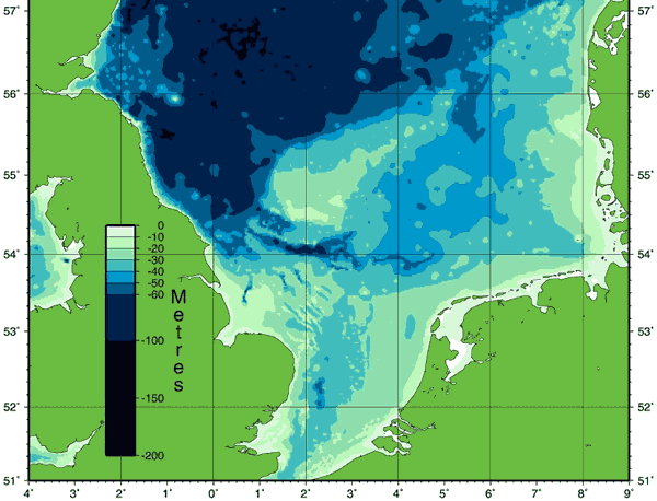
The possibility of seismic activity is underlined by the “dormant” Zuidwal volcano that is apparently lurking 2 kilometres beneath the Wadden Sea.
The Zuidwal volcano is an extinct volcano in the Netherlands at more than 2 km (6,600 ft) below ground under the Wadden Sea, between Harlingen and Vlieland, just south west of the island Griend.
The volcano was last active during the late Jurassic, (about 160 – 148 Ma ago) and has since been covered by about 2,000 metres (6,600 ft) of sedimentary rock, most of it shale and sandstone from the Cretaceous.
Discovery
The volcano was discovered in 1970 when the French oil company Elf Aquitaine was doing test drills in the Wadden Sea, hoping to find a gas field that a seismic survey had indicated.To their surprise they hit volcanic rock beneath the reservoir rock, which turned out to be an extinct volcano. The gas field went in production in 1988 and is still producing gas.
Another clue indicating the presence of the volcano was the temperature.
While the usual temperature at that depth is about 100 °C (212 °F), they found 130 °C (266 °F).
The Volcano
The volcano has a height of approximately 1 km (3,300 ft) and was formed about 160 million years ago, during a time of orogenesis on the European continent.The eruptions were short and severe with heavy explosions.
This, along with the mineral composition, points to volcanic activity as a result of subduction far away from the volcano.
During the Cimmerian Orogeny, the Cimmerian Plate collided with Kazakhstania, sending shock waves through the Eurasian Plate, resulting in volcanism.
The volcano is covered by layers of sandstone from the early Cretaceous that act as reservoir rock for the gas. The seal rock consists of shale.
The volcanic rock is magnetic, creating a magnetic anomaly.
Returning to Wikipedia it is apparent that Wikipedia doesn’t consider seismic activity even though the island of Strand was “split” [“torn apart”] into three separate islands while The Nübbel and Nieland Halligen simply “submerged in the sea”.
Strand was an island on the west coast of Nordfriesland in the Duchy of Schleswig, which was a fiefdom of the Danish crown.
…
In 1634, the Burchardi flood split Strand island into Nordstrand, Pellworm, and Nordstrandischmoor.https://en.wikipedia.org/wiki/Strand_%28island%29
On Strand alone, at least 6,123 people lost their lives due to 44 dike breaches, which relates to two thirds of the entire population of the island.
And the island of Strand was torn apart, forming the smaller islands Nordstrand and Pellworm and the Halligen Südfall and Nordstrandischmoor.
The Nübbel and Nieland Halligen submerged in the sea.

Wikipedia attributes the Burchardi flood to “insufficient maintenance” coupled with a “strong storm” which [upon closer inspection] is classified as one of the “strongest extratropical cyclones” [aka European Windstorm].
Course of events
While the weather had been calm for weeks prior to the flood, a strong storm occurred from the east on the evening of 11 October 1634 which turned southwest during the evening and developed into a European windstorm from the northwest.https://en.wikipedia.org/wiki/Burchardi_flood
European windstorm is a name given to the strongest extratropical cyclones which occur across the continent of Europe.
They form as cyclonic windstorms associated with areas of low atmospheric pressure, sometimes starting as nor’easters off the New England coastline, that track across the North Atlantic Ocean towards western Europe.
They are most common in the autumn and winter months.
https://en.wikipedia.org/wiki/European_windstorm

Those who experienced the Burchardi flood thought it was “divine punishment” and Anna Ovena Hoyer described it as “the beginning of the apocalypse”.
The people of the time could only imagine such a flood as a divine punishment from God.
The evangelical enthusiast and poet Anna Ovena Hoyer interpreted the Burchardi Flood as the beginning of the apocalypse.
https://en.wikipedia.org/wiki/Burchardi_flood
Anna Ovena Hoyer (1584 – 27 November 1655) was a writer and poet, originally German; active in Sweden from 1632.
…
In 1634 she visited Hoyersworth and experienced in October the devastating Burchardi flood.
Other sources specifically report earthquakes during the Burchardi flood.
In his North Frisian Chronicle [Nordfresische Chronika – 1666], Antonius Heimreich described the catastrophic flooding of 11 October 1634, in which the island called the ‘Strand’ went under.
This ‘monstrous storm was mixed with a shaking of the earth‘, which was felt as far as the east coast.
Fissures opened in the earth, and in several places the ground ‘split wide apart’.
The walls of houses cracked and, ‘Trustworthy persons have given it for truth, that the beds in which they lay, and others, the chairs in which they sat at table, were moved and shaken to and fro’ (1666, p.479).
Atlantis of the North – Jurgen Spanuth – English Translation: 1979
Furthermore, it appears that Peter Sax [who gave Wikipedia their abbreviated poetic quotation: “Earth’s foundation was shaken…” – see above] was actually referring to earthquakes.
Peter Sax who experienced the same catastrophe on the mainland at Koldenbuttel, also spoke of earthquakes which were felt on that day and said that ‘the foundations of the earth moved, and one could not but think that heaven and earth would fall apart, and the last day was at hand’.
Atlantis of the North – Jurgen Spanuth – English Translation: 1979
Overall, the mainstream Burchardi flood narrative based upon a “strong storm”, “insufficient maintenance” and a “washed away” island is not the whole story.
In other words: Beware Academics Bearing Storms because they have a nasty habit of:
a) Downplaying The Little Ice Age.
b) Blaming humans for natural catastrophes.
c) Ignoring evidence e.g. seismic activity.
d) Writing narratives that strictly conform to their gradualist belief system.
See: https://en.wikipedia.org/wiki/Uniformitarianism
Bless their little [very threadbare] cotton socks.

Any geomagnetic perturbations assigned to this period? Land subsidence seems to be due to release of subterranean natural gas, in like manner as asserted by the late Lance Endersby, an Australian engineer formally of Snowy Mountains Scheme, and global groundwater geology. Drawing subterranean water, as in California specifically during the 1930’s, also caused land subsidence. Once out the water never gets back into the crust and it, the crust, collapses or subsides. Lots to research – thanks 🙂
The geology of the North Sea presents a few challenges 🙂
Usually when this happens we have a thrust as the mechanism assuming the dating is tickety-boo……which seems not the case here……. Triassic rocks here in OZ are also ‘reddish’. Hmmmmm and another headache.
Not so mysterious – salt dome intrusion to west but the only subsurface data is a drill hole bored in 1938. Might be a challenge for those who have difficulty visualising 3D structures in the subsurface. Headache gone.
Pingback: Iceland Goes South | MalagaBay