

IF Jupiter has released a series of planets into the inner Solar System
THEN the data suggests the Axial Tilt and Heliocentric Inclination of these planets approaches zero as their orbital distance from the Sun approaches zero.
Mercury, for example, with a Semi-major Axis of 0.387098 AU has an Axial Tilt of 0.01 degrees and a Heliocentric Inclination of 0.245 degrees.

The more distant Moon, with a Semi-major Axis of [about] 1 AU, has an Axial Tilt of 1.54 degrees and a Heliocentric Inclination of 2.11 degrees.
The transition towards zero Axial Tilt appears to be relatively modest if their Axial Tilts were inherited from Jupiter which has an Axial Tilt of 3.13 degrees.
Whilst the transition towards zero Axial Tilt for the Saturn Family of planets would be far more extreme if they originally inherited Saturn’s Axial Tilt of 26.73 degrees.

Furthermore, if the transition in Axial Tilt occurs too rapidly then it is not unreasonable to anticipate that the planet’s crust may become deformed, cracked or [in extreme cases] completely stripped away.

Within this context, therefore, it is worthwhile reviewing the Settled Science of Earth’s Axial Tilt especially as Mars is sporting surface scars and Earth’s surface shows signs of splitting.


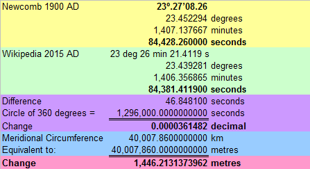
Firstly, the Earth’s Axial Tilt is currently determined to be 23 degrees 26 minutes 21.4119 seconds.
Obliquity of the ecliptic for the epoch J2000.0 23°26’21”.4119
Earth Orientation Center – Earth’s rotation constants
http://hpiers.obspm.fr/eop-pc/models/constants.html
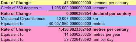
Secondly, the Earth’s Axial Tilt is currently declining at a rate of about 47 seconds per century.
The Earth currently has an axial tilt of about 23.4°.
…
At present, it is decreasing at a rate of about 47″ per century.
Although “about 47″ per century” is casually thrown into the pot of information this figure equates to a meridional movement of about 14.51 metres per year or 39.72 millimetres per day.
Circumference 40 075.017 km (equatorial) 40 007.86 km (meridional)
https://en.wikipedia.org/wiki/Earth

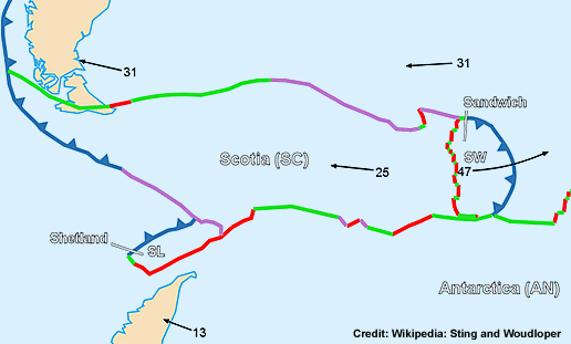
In geologic terms this is extremely fast even in comparison to the East Scotia Ridge which only manages a sprightly spreading rate of 60 to 90 millimetres per year.
The Scotia Plate (Spanish: Placa Scotia), named after the Scotia Sea, which overlies it, is a tectonic plate on the edge of the South Atlantic and Southern Ocean.
…
The eastern edge of the Scotia plate is a spreading ridge bounded by the South Sandwich microplate forming the East Scotia Ridge.The East Scotia Ridge is a back-arc spreading ridge that formed due to subduction of the South American plate below the South Sandwich plate along the South Sandwich Island arc.
Exact spreading rates are still being disputed in the literature, but it has been agreed that rates range between 60–90 mm/yr.
https://en.wikipedia.org/wiki/Scotia_Plate

Now this is where things start to get really interesting because the Geographic North Pole [the point in the Northern Hemisphere where the Earth’s axis of rotation meets the surface] has only moved by about 20 metres since 1900 whilst the axis of rotation itself has moved by about 1,446 metres.
The North Pole, also known as the Geographic North Pole or Terrestrial North Pole, is, subject to the caveats explained below, defined as the point in the Northern Hemisphere where the Earth’s axis of rotation meets its surface.
https://en.wikipedia.org/wiki/North_Pole
Polar motion of the Earth is the movement of the point where Earth’s rotational axis intersects its surface.
This is measured with respect to a reference frame in which the solid Earth is fixed (a so-called Earth-centered, Earth-fixed or ECEF reference frame).
This variation is only a few meters.
…
The slow drift, about 20 m since 1900…
https://en.wikipedia.org/wiki/Polar_motion
The Chandler wobble is a small deviation in the Earth’s axis of rotation relative to the solid earth, which was discovered by American astronomer Seth Carlo Chandler in 1891.
It amounts to change of about 9 metres (30 ft) in the point at which the axis intersects the Earth’s surface and has a period of 433 days.
This wobble, which is a nutation, combines with another wobble with a period of one year, so that the total polar motion varies with a period of about 7 years.
https://en.wikipedia.org/wiki/Chandler_wobble


In other words, the surface of the Earth is moving almost synchronously with the slightly wobbly axis of rotation as the Axial Tilt slowly decreases over the years [give or take 20 metres slippage].
The analysis of Geographic North Pole Motion by [the conveniently forgetful] Wikipedia makes no direct mention of the continuously changing Axial Tilt although their “longer term variation which is less well understood” may be an indirect reference.
Analysis
It consists of two quasi-periodic components and a gradual drift, mostly in the direction of the 80th meridian west, of the Earth’s instantaneous rotational axis or North pole, from a conventionally defined reference axis, the CIO (Conventional International Origin), being the pole’s average location over the year 1900.The two periodic parts are a more or less circular motion called Chandler wobble with a period of about 435 days, and a yearly circular motion.
There is also a longer term variation which is less well understood.
One of the reasons why the mainstream is so conveniently forgetful is because it wants to debunk the Pole Shift Hypothesis and indirectly discredit its proponents [such as Charles Hapgood].
The cataclysmic pole shift hypothesis suggests that there have been geologically rapid shifts in the relative positions of the modern-day geographic locations of the poles and the axis of rotation of the Earth, creating calamities such as floods and tectonic events.
…
Charles Hapgood is now perhaps the best remembered early proponent.In his books The Earth’s Shifting Crust (1958) (which includes a foreword by Albert Einstein) and Path of the Pole (1970), Hapgood, building on Adhemar’s much earlier model, speculated that the ice mass at one or both poles over-accumulates and destabilizes the Earth’s rotational balance, causing slippage of all or much of Earth’s outer crust around the Earth’s core, which retains its axial orientation.
Based on his own research, Hapgood argued that each shift took approximately 5,000 years, followed by 20,000- to 30,000-year periods with no polar movements.
Also, in his calculations, the area of movement never covered more than 40 degrees.
Hapgood’s examples of recent locations for the North Pole include Hudson Bay (60˚N, 73˚W), the Atlantic Ocean between Iceland and Norway (72˚N, 10˚E) and Yukon (63˚N, 135˚W).
However, in his subsequent work The Path of the Pole, Hapgood conceded Einstein’s point that the weight of the polar ice would be insufficient to bring about a polar shift.
Instead, Hapgood argued that the forces that caused the shifts in the crust must be located below the surface.
However, the mainstream does acknowledge that “true polar wander” does occur and that “during the last 200 million years a total true polar wander of some 30° has occurred”.
There is evidence of precession and changes in axial tilt, but this change is on much longer time-scales and does not involve relative motion of the spin axis with respect to the planet.
However, in what is known as true polar wander, the solid Earth can rotate with respect to a fixed spin axis.
Research shows that during the last 200 million years a total true polar wander of some 30° has occurred, but that no super-rapid shifts in the Earth’s pole were found during this period.
A characteristic rate of true polar wander is 1° or less per million years
https://en.wikipedia.org/wiki/Pole_shift_hypothesis
True polar wander is a solid-body rotation of a planet or moon with respect to its spin axis, causing the geographic locations of the North and South Poles to change, or “wander”.
https://en.wikipedia.org/wiki/True_polar_wander
True polar wander represents the shift in the geographical poles relative to Earth’s surface, after accounting for the motion of the tectonic plates.
This motion is caused by the rearrangement of the mantle and the crust in order to align the maximum inertia with the current rotation axis.
But what the mainstream fails to mention is that if Axial Tilt is changing at a rate of about 47″ per century then the Geographic North Pole would have travelled 2,901,804.66 kilometres [the equivalent to 72.53 trips around the Earth] during those 200 million years.

However, according to the Mainstream Master Plan, these 2,901,804.66 kilometres would have been achieved by the Geographic North Pole bouncing backwards and forwards between 22.1° and 24.5°.
For the past 5 million years, Earth’s obliquity has varied between 22° 02′ 33″ and 24° 30′ 16″, with a mean period of 41,040 years.
This cycle is a combination of precession and the largest term in the motion of the ecliptic. For the next 1 million years, the cycle will carry the obliquity between 22° 13′ 44″ and 24° 20′ 50″.
The movement of the Geographic North Pole is most likely achieved by sliding the “rigid” lithosphere over the “highly viscous, mechanically weak” asthenosphere because crustal movement [or deformation] is not observed to be occurring at the required rate of 39.72 millimetres per day.
A lithosphere is the rigid, outermost shell of a rocky planet, and can be identified on the basis of its mechanical properties.
On Earth, it comprises the crust and the portion of the upper mantle that behaves elastically on time scales of thousands of years or greater.
https://en.wikipedia.org/wiki/Lithosphere
The asthenosphere is the highly viscous, mechanically weak and ductilely deforming region of the upper mantle of the Earth.
It lies below the lithosphere, at depths between ≈80 and ≈200 km (≈ 50 and 124 miles) below the surface.
https://en.wikipedia.org/wiki/Asthenosphere


Thus it is also likely that the rate of change in the Axial Tilt of the Earth is associated with volcanic activity because sliding the lithosphere over the asthenosphere will cause frictional heating.
The Earth Scientists, in their infinite wisdom, have resorted to inventing volcanic processes because they won’t countenance any theory that lends credence to the Pole Shift Hypothesis.
Earth’s internal heat comes from a combination of residual heat from planetary accretion (about 20%) and heat produced through radioactive decay (80%).
https://en.wikipedia.org/wiki/Earth#Composition_and_structure
This figure is a snapshot of one time-step in a model of mantle convection.
Colors closer to red are hot areas and colors closer to blue are cold areas.https://en.wikipedia.org/wiki/Mantle_%28geology%29
Movement of molten rock in the mantle, caused by thermal convection currents, coupled with gravitational effects of changes on the earth’s surface (erosion, deposition, even asteroid impact and patterns of post-glacial rebound) drive plate tectonic motion and ultimately volcanism.
https://en.wikipedia.org/wiki/Volcanism#Driving_forces_of_volcanism

The Eccentric Astronomers, in an act of humongous Newtonian hubris, have invented a Mainstream Million Year Master Plan that dictates [in the first instance] that the Earth’s Axial Tilt will stop decreasing in about 3,255 years before it embarks upon a return trip to about 24°.
Obliquity of the ecliptic for the past 5 million years, from Berger (1976).
Note that the obliquity varies only from about 22.0° to 24.5°.
The red point represents the year 1850.

The mainstream Earth Historians, in an act of abject academic abasement, appear to be fully committed to tailoring their narratives to fit the Mainstream Million Year Master Plan.
Now the reason the sun does not rise and set in the same places every day is because the axis of the earth’s rotation is not perpendicular to the plane of the earth’s path round the sun.
In fact the earth’s axis is inclined at an angle of some 23½° away from the perpendicular.
It is this fact which accounts for the seasons of the year, the alterations in the lengths of day and night, and the different positions occupied by the sun at the times of rising and setting.
This angle between the earth’s rotational axis and the perpendicular to the earth’s path round the sun is, of course, the same as the angle between the plane of the earth’s equator and the plane of the ecliptic (or the earth’s path) and is called ” the obliquity of the ecliptic.”
The mutual attractions between the other planetary bodies of the solar system and the earth have the effect of moving the plane of the ecliptic in space.
This alters the obliquity of the ecliptic.
This change in the obliquity is very gradual and has only amounted to half a degree (that is, the dia1neter of the sun) in the last four thousand years.
…
The result of this survey showed widely discrepant values from those used by Sir N. Lockyer and gave an impossible date for the foundation of the te1nple.
…
…
Substituting in the formula we get the obliquity of the ecliptic for the year 4000 B.C. to be:-ω = 24° 6′ 39″•6.
This we see differs by more than a degree from the required obliquity to make the sun shine down the axis at 4000 B.C., which is about the time of the supposed foundation of the temple.
We also see that since 4000 B.C. up to the present day the obliquity of the ecliptic has only decreased by some 40′.
Also, if the sun shone down the axis of the temple at the date of its foundation it has since decreased by more than 100’, which would give a ridiculous date for the foundation of the temple.
…
There is thus no reason to suppose that the temple of Amen-Ra at Karnak was originally laid down to have any relation whatever with the position of the setting sun at the time of summer solstice.Note on the Age of the Great Temple of Ammon at Karnak as Determined by the Orientation of its Axis – F. S. Richards – 1921 – Survey of Egypt Paper No. 38
http://www.cfeetk.cnrs.fr/fichiers/Documents/Ressources-PDF/documents/K1154-RICHARDS.pdf

However, way back in 1935, George Dodwell tried in vain to inform the Royal Astronomical Society that observations of the Earth’s Axial Tilt indicated the Earth had been wilfully disregarding the Mainstream Million Year Master Plan for at least 4,194 years.
In 1935 I sent a preliminary paper to the Royal Astronomical Society, dealing with the results so far obtained at that time.
It was returned to me by referees, with a note that the errors of the ancient observations needed further discussion.
It was the general opinion of astronomers at that time, and still is, that the differences of the ancient observations of the obliquity of the ecliptic from Newcomb’s formula are wholly due to errors of the ancient observations.
…
The advice given at that time by the reviewers was most valuable, and I decided to examine the conditions of error in the ancient observations in a practical way, by constructing and using a type of vertical gnomon for solstitial observations of the sun, similar to the gnomons used in ancient times.This was thoroughly tested at the Adelaide University at the June (southern winter) solstice of the year 1936.
Nine observers took part in the observations, and 172 observations were made.
…
The results confirm the general accuracy of the ancient observations, within one or two minutes of arc; and they show also that in a long series of such observations by a careful observer (such as the observations made by Eratosthenes during his 40 years work at Alexandria), no great errors occur.
…
I hoped this work might be published as a product of the Adelaide Observatory, for distribution to other observatories, and for astronomers to examine.But its publication has been delayed.
George F. Dodwell – Wayville, South Australia, October 1962.
Author’s Preface – The Obliquity of the Ecliptic
http://www.setterfield.org/Dodwell/Dodwell_Manuscript_1.html

The observational data provided by George Dodwell can now be extended with an additional data point for 2015 so that the Earth’s Axial Tilt can be graphed for the last 200 years.
Source: Dodwell’s Data Table – The Obliquity of the Ecliptic – George F. Dodwell
http://www.setterfield.org/Dodwell/Dodwell_Manuscript_1.html


The data for the last 115 years clearly indicates the Earth has been wilfully disregarding the Mainstream Million Year Master Plan and suggests the Earth’s Axial Tilt will start reversing direction around the middle of this century.

The data also clearly indicates that it’s Game Over for the Mainstream Million Year Master Plan and the multitude of mathematical monstrosities modelled around Newton’s Law of Universal Gravitation.
If only the normal gravitational effects of the celestial bodies were involved, a quite impossible situation would thus arise for the astronomical dating of the Temple, just as the Surveyor General of Egypt pointed out.
But it is evidently not so, for the clear and factual accounts of the foundation ceremonies, carried out by the Kings of Egypt themselves as an impressive act of their religious duty in the founding of a Solar Temple, the nature of the instruments they used, the simplicity of the observations, and the special use of the temple of Karnak in particular, made by the Egyptian priest-astronomers, for astronomical and religious purposes, including the keeping of the Egyptian Calendar, and the dramatic “Manifestation of Ra” – all these are so clearly established, that we cannot escape the conclusion that there must be some other factor, in addition to those which are represented by Newcomb’s Formula (or equally by Stockwell’s Formula), affecting the sun’s apparent position in past ages.
Ancient Oriented Monuments – The Obliquity of the Ecliptic – George F. Dodwell
http://www.setterfield.org/Dodwell/Dodwell_Manuscript_1.html
Unfortunately, the timing of this reversal in Axial Tilt motion may be a harbinger of a half-cycle Lawler Event.
In 1990 J. H. L. Lawler published a historical review of empires and civilisations which closely reflects the 1,350 year climate cycle and highlights the importance of the half-cycle period of 675 years.
…
The importance of the 1,350 year climate cycle becomes interesting when you remember that the Little Ice Age has been “conventionally defined” as starting in 1,350 AD [perhaps there is more to our calendar than meets the eye] because adding on the half-cycle period of 675 years brings us to 2,025 AD.
Solar System: Holocene Lawler Events

In which case this reversal in Axial Tilt motion will be a serious Game Over event.

Cycles on cycles on cycles – the human mind is fascinated with predictions but I wonder if circular reasoning has been in play as well.
And polar wander – the uniformist assumption is that the earth has not moved axially around its axis of spin, apart from a few measured wobbles, since the beginning. Hence the couple polar-wandering is described by magnetic pole wandering ? Which pole do they mean when they write ‘polar wandering’ ?
It’s why plate tectonics was proposed – how to explain the palaeomagnetic record on the assumption of a static earth wrt to its axis of rotation and the generation of the geomagnetic field inside the core.
But now we know the Earth is associated with a co-rotating torus of electric charge, the Van Allen Belts, and from an electical engineering POV the geomagnetic field should be produced by the Van Allen Belts, not from you unobserved but guessed at internal mechanism.
Perhaps it should be named as “The Wandering Poles”? (Apologies to Gilad Atzmon).
South Atlantic anomaly and magnetic north pole are possible signs ?
http://www.nat-hazards-earth-syst-sci.net/13/3395/2013/nhess-13-3395-2013.html
“….That the GSL is somehow connected with SAA is also confirmed by the similar result when an analogous critical-like fit is performed over GSL: the corresponding critical point (2033 ± 11 yr) agrees, within the estimated errors, with the value found for the SAA. From this result, we point out the intriguing conjecture that tc would be the time of no return, after which the geomagnetic field could fall into an irreversible process of a global geomagnetic transition that could be a reversal or excursion of polarity…”
http://www.ngdc.noaa.gov/geomag/data/poles/NP_Arc2Feb2014.xy
http://daltonsminima.altervista.org/wp-content/comment-image/120711.jpg
The speculative conclusions in the Toward a possible next geomagnetic transition? paper suggest a Lawler Event is possible…
But it looks like they are using Global Warming infected sources for their sea-level data.
My preference is for the “alternative view” presented by Nils-Axel Mörner….
We are definitely in the market for a driving mechanism for crustal movement as it is now crystal clear that mantle convection does not exist. However, it is also clear that very substantial geomagnetic excursions can occur without matching axis of rotation shifts.
The classic example is the @ 40kya “reversal” which registers as a complete reversal by the alignment of magnetic sediments in some places, but registering different trajectories and incomplete reversal from the perspective of magnetic sediments in other places.
Annoyingly quantum.
gymnosperm says:
April 11, 2015 at 07:38
We are definitely in the market for a driving mechanism for crustal movement as it is now crystal clear that mantle convection does not exist.
My suggestion for the mechanism of crustal movement is:
collapse of the crust onto the contracting and solidifying core.
There is a temp gradient between the core and the surface. This gradient is best removed when the core has maximum surface area. That is the core is a tetrahedron. The crust collapses onto it. Continents are along the edges and at the corners. Oceans are in depressions in the faces
The Tetrahedral Earth theory explains the two most significant features of the Earth:
!. The position of the continents.
2. The tilt of the rotation
The theory can be extended to all the planets.
It is based on only simple heat transfer in a solid and geometry.
.
It’s regrettable that Dodwell has been ignored and the measurements of Hipparchus branded as erroneous because they don’t ‘fit’ modern thinking. It smacks of arrogance IMO, when they know Newcomb and his successors have not been able to get it right about axial tilt.
Dodwell was the Government Astronomer for South Australia for over 40 years, hardly a crank.
Discussion of Dodwell’s research here:
Talkshop commenter Carol wrote:
I’ve come across an interesting article in the NCGT journal (geology) March 2015 which is at http://www.ncgt.org/newsletter.php – click on March and trawl down to page 71-86. I would be interested what you might think. The idea is that Earth’s rotation may periodically wobble, and the spin rate change temporarily. The author, Peter M James of Tasmania, appears to provide some useful mechanism for anomalies of the past – and even as recently as a few centuries ago. These include the eclipse calculations of Eratosthenes and Hipparchus, and those of Ptolemy. Modern astronomers are perplexed at them as they do not conform with modern retro-calculations. Eclipses very often do occur on the dates claimed – but in different places where alleged. Other eclipse data is perfectly okay with modern retro-calculations which has led to the accusation that ancient astronomers were not precise enough – but Hipparchus was the most meticulous of people, and Eratosthenes was likewise famed for his prowess.’
Pingback: All Gyre and No Gimbals | MalagaBay
Pingback: Solar Rotation – Formula Fantasies | MalagaBay
This is 2 years later: oldbrew’s ‘carol’ link refers to an NCGT article. A second following article by same author provides some interesting info/dates on the subject of ‘Axial Tilt’. Since the articles are no longer freely available I an including a section from the second one named “THE PATTERN OF GLOBAL CATACLYSMS” (pg 91).
“—global destructions and climatic changes at the time of Egypt’s Dark Age, this was not a “first” cataclysm of the Holocene. The epic of Gilgamesh speaks of the gates of the Lower Ocean being knocked down and humans filling the sea like the spawn of fish. Gilgamesh was the fifth king of Uruk, which places him in the closing centuries of the fourth millennium BC – a thousand years or more prior to Egypt’s First Dark Age. An even earlier destruction level, in the form of a silt bed, was exposed by Woolley at nearby Ur. This has been dated around 4500 BC, or more than a millennium before Gilgamesh. At around 4500 BC, Byblos – on the Mediterranean coast of what is now Lebanon – suffered destruction. An even earlier destruction is indicated by the history of Catal Huyuk, on the Konya Plain in Turkey. Situated at about 1000 m above sea level, Catal Huyuk had irrigation techniques in use by 6250 BC, indicating a thriving culture. Its abandonment is dated as 5400 BC, although small settlements around continued it into the next millennium. Jericho, built on an oasis 250 m below sea level, was a thriving centre of farming and trading as far back as the beginning of the Holocene. It is unclear why it was initially abandoned at some stage around 7200 BC but the site was later taken up by a people who left remains to suggest an exceptional level of civilisation. By the sixth millennium BC, Jericho was probably a jewel in the Neolithic crown. But it all came to an end and the four metre high city walls crumbled, the city mound became eroded by erosion, and the next inhabitants of this oasis were another inferior breed, living in open villages, with simple pottery, simple tools, simple life styles. Severe droughts have been cited as the cause of Jericho’s abandonment, but Jericho was built beside an oasis which means its water supply was tied to the regional ground water table and one would have thought this could have withstood the effects of the severest drought. Moreover, the erosion of the city walls does not sound like the result of a drought. So, the idea of a “flood” is not to be ruled out.”
Two years later those dates are corroborated by additional evidence, the basis of which are ’tilt changes’. I link again to the material (my own). Note how the dates correspond to the proxies and to the subject of my research. (Dates: 4500= ~4375; 5400=same; 6250=~6200; ) . Latest reference appeared in 2017. Additional local archaeological megalithic examples also appeared in print this year.