

Mainstream academics have determined that world-wide floods and deluges must be myths because they are incompatible with their Historic Truth and Settled Science narratives.
The flood myth motif is widespread among many cultures as seen in the Mesopotamian flood stories, the Hindu religious books from India called Puranas, Deucalion in Greek mythology, the Genesis flood narrative, and in the lore of the K’iche’ and Maya peoples in Mesoamerica, the Lac Courte Oreilles Ojibwa tribe of Native Americans in North America, the Muisca people, and Cañari Confederation, in South America.
…
A world-wide deluge, such as described in Genesis, is incompatible with modern understanding of the natural history and especially geology and paleontology.
Instead of world-wide floods and deluges the mainstream prefers to promote their Ice Ages narrative although they admit that the “causes of ice ages are not fully understood”.
There have been at least five major ice ages in the earth’s past (the Huronian, Cryogenian, Andean-Saharan, Karoo Ice Age and the Quaternary glaciation).
Outside these ages, the Earth seems to have been ice-free even in high latitudes.
Rocks from the earliest well established ice age, called the Huronian, formed around 2.4 to 2.1 Ga (billion years) ago during the early Proterozoic Eon.
…
The causes of ice ages are not fully understood for either the large-scale ice age periods or the smaller ebb and flow of glacial–interglacial periods within an ice age.

In other words: Ice Ages are mainstream myths without scientific foundation.
Having manufactured their Ice Age myths the mainstream still have to account for a few inconvenient mega-floods [whilst very carefully avoiding the Inflating Earth narrative].
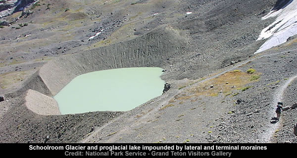
Lake Bonneville
The first scientific report of a megaflood (Gilbert, 1890) is that related to the overflow of Lake Bonneville about 14500 yr ago, during the Pleistocene.
…
The Black Sea (around 7,600 years ago)
A rising sea flood, recently disclosed[clarification needed] and much-discussed refilling of the freshwater glacial Black Sea with water from the Aegean, was described as “a violent rush of salt water into a depressed fresh-water lake in a single catastrophe that has been the inspiration for the flood mythology” (Ryan and Pitman, 1998).
…
The Caspian and Black Seas (around 16,000 years ago)
A theory proposed by Andrey Tchepalyga of the Russian Academy of Sciences dates the flooding of the Black Sea basin to an earlier time and from a different cause.
…
Red Sea floods
The barrier across Bab el Mandib, between Ethiopia and Yemen, seems to have been the source of outbreak flooding similar to that found in the Mediterranean.
…
The refilling of the Mediterranean Sea (5.3 million years ago)
A catastrophic flood refilled the Mediterranean Sea 5.3 million years ago, at the beginning of the Zanclean age that ended the Messinian salinity crisis.
When all else fails the mainstream whips out it’s Etch A Sketch, doodles in a few ice sheets [any time – any place], colours-in a proglacial lake [or two] and invokes their universal catastrophic release of dammed water myth [aka get out of jail for free card].
In geology, a proglacial lake is a lake formed either by the damming action of a moraine or ice dam during the retreat of a melting glacier, or by meltwater trapped against an ice sheet due to isostatic depression of the crust around the ice.
At the end of the last ice age approximately 10,000 years ago, large proglacial lakes were a widespread feature in the northern hemisphere.
In some cases, such lakes gradually evaporated during the warming period after the Quaternary ice age.
In other cases, such as Glacial Lake Missoula and Glacial Lake Wisconsin in the United States, the sudden rupturing of the supporting dam caused glacial lake outburst floods, the rapid and catastrophic release of dammed water resulting in the formation of gorges and other structures downstream from the former lake.
Good examples of these structures can be found in the Channeled Scablands of eastern Washington, an area heavily eroded by the Missoula Floods.
In Great Britain, Lake Lapworth, Lake Harrison and Lake Pickering were examples of proglacial lakes.
Ironbridge Gorge in Shropshire and Hubbard’s Hills in Lincolnshire are examples of a glacial overspill channel created when the water of a proglacial lake rose high enough to breach the lowest point in the containing watershed.
https://en.wikipedia.org/wiki/Proglacial_lake
See: https://malagabay.wordpress.com/2013/07/19/etch-a-sketch-ice-sheets/
English Channel floods
Originally there was an isthmus across the Strait of Dover.
During an earlier glacial maximum, the exit from the North Sea was blocked to the north by an ice dam, and the water flowing out of rivers backed up into a vast lake with freshwater glacial melt on the bed of what is now the North Sea.
…
Glacial lake outburst floods in North America (15,000 to 8,000 years ago)
In North America, during glacial maximum, there were no Great Lakes as we know them, but “proglacial” (ice-frontage) lakes formed and shifted.They lay in the areas of the modern lakes, but their drainage sometimes passed south, into the Mississippi system, sometimes into the Arctic, or east into the Atlantic.
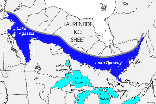
The most famous of these proglacial lakes was Lake Agassiz.
A series of floods, as ice-dam configurations failed, created a series of great floods from Lake Agassiz, resulting in massive pulses of freshwater added to the world’s oceans.
The Missoula Floods of Oregon and Washington states were also caused by breaking ice dams, resulting in the Channeled Scablands.
https://en.wikipedia.org/wiki/Outburst_flood
Lake Ojibway was a prehistoric lake in what is now northern Ontario and Quebec in Canada.
Ojibway was the last of the great proglacial lakes of the last ice age.
Comparable in size to Lake Agassiz (to which it is likely to be linked), and north of the Great Lakes, it was at its greatest extent c. 8,500 years BP.
The former lakebed forms the modern Clay Belt, an area of fertile land.
Lake Ojibway was relatively short-lived.
The lake drained in what must have been a catastrophic and dramatic manner around 8,200 years BP.
One hypothesis is that a weakening ice dam separating it from Hudson Bay broke, as the lake was roughly 250 m (820 ft) above sea level.
A comparable mechanism produced the Missoula floods that created the channeled scablands of the Columbia River basin.
A recent analysis states it has not been conclusively determined whether the lake drained by a breach of the ice dam, by water spilling over the glacier, or by a flood under the glacier.
It is also not conclusively known whether there were one or more pulses, and the route the water took to reach Hudson’s Bay has not been determined.

The mainstream maintains two versions of the catastrophic release of dammed water myth.
The version one myth relies upon a proglacial lake being dammed by a moraine before a sudden rupture triggers a “catastrophic release” [aka mega-flood].
A moraine is any glacially formed accumulation of unconsolidated glacial debris (soil and rock) that occurs in currently glaciated and formerly glaciated regions on Earth (i.e. a past glacial maximum), through geomorphological processes.
Moraines may be composed of debris ranging in size from silt-sized glacial flour to large boulders.
The debris is typically sub-angular to rounded in shape.
Moraines may be on the glacier’s surface or deposited as piles or sheets of debris where the glacier has melted. Moraines may also occur when glacier- or iceberg-transported rocks fall into a body of water as the ice melts.
However, there are two major problems with the dammed by a moraine myth.
Firstly, moraines are easily breached because they are primarily composed of silt-sized glacial flour.
A terminal moraine, also called end moraine, is a moraine that forms at the snout of a glacier, marking its maximum advance.
…
At this point, the debris that has been accumulated by plucking and abrasion, that has been pushed by the front edge of the ice is driven no farther, but instead is dumped in a heap.Because the glacier acts very much like a conveyor belt, the longer it stays in one place, the greater the amount of material that will be deposited.
The moraine is left as the marking point of the terminal extent of the ice.
https://en.wikipedia.org/wiki/Terminal_moraine
Rock flour, or glacial flour, consists of fine-grained, silt-sized particles of rock, generated by mechanical grinding of bedrock by glacial erosion or by artificial grinding to a similar size.
Because the material is very small, it becomes suspended in meltwater making the water appear cloudy, which is sometimes known as glacial milk.
When the sediments enter a river, they turn the river’s colour grey, light brown, iridescent blue-green, or milky white.
If the river flows into a glacial lake, the lake may appear turquoise in colour as a result.
https://en.wikipedia.org/wiki/Rock_flour
Glaciation in Glacier National Park – Madeleine Rushing – 26 August 2013
American Geophysical Union – AGU Blogsphere


Secondly, large scale moraines form low, irregular barriers with numerous melt water breaches.

The version two myth relies upon a proglacial lake being dammed by ice before a sudden rupture triggers a “catastrophic release” [aka mega-flood].
However, the problem with Ice Dams is that they are fairly useless at holding back water – as the engineers at Fukushima recently discovered [the hard way].
Tepco ran into technical difficulties with its most recent plan, the construction of underground walls of frozen water to prevent contaminated water from reaching the ocean.
…
But the company has since discovered that the water does not freeze as easily as expected due various factors.Ice wall failure sends Tepco back to drawing board
Nikkei Asian Review – 21 November 2014
http://asia.nikkei.com/Business/Companies/Ice-wall-failure-sends-Tepco-back-to-drawing-board
This is because melt water creates tunnels [aka moulins aka ice caves] and channels which allow the water to flow over, through and beneath [both] glaciers and ice sheets.
A moulin or glacier mill is a roughly circular, vertical to nearly vertical well-like shaft within a glacier through which water enters from the surface.
…
Moulins can reach the bottom of the glacier, hundreds of meters deep, or may only reach the depth of common crevasse formation (about 10–40 m) where the stream flows englacially.They are the most typical cause for the formation of a glacier cave.
Moulins are a part of a glacier’s internal “plumbing” system, that carry meltwater from the surface down to wherever it may go.
https://en.wikipedia.org/wiki/Moulin_%28geology%29
Most glacier caves are started by water running through or under the glacier.
This water often originates on the glacier’s surface through melting, entering the ice at a moulin and exiting at the glacier’s snout at base level.
https://en.wikipedia.org/wiki/Glacier_cave


Therefore, the internal plumbing system of glaciers and ice sheets allow melt water to reach the underlying bedrock where it then follows the natural drainage system in the underlying terrain.
See: https://malagabay.wordpress.com/2014/12/05/the-great-greenland-snow-job-06-the-64000-question/

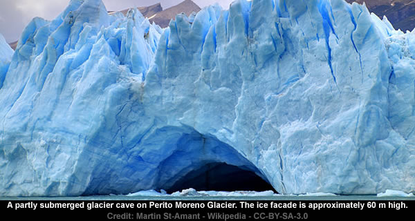
The short lifespan of Ice Dams and the tunnelling properties of water are well illustrated by the Perito Moreno Glacier in Argentina which displays a “dam–ice-bridge–rupture cycle” where, for example, the 23rd Nov 2012 Ice Dam collapsed on 19th Jan 2013.
Roughly every four years the glacier forms an ice dam against the rocky coast, causing the waters of the Lago Argentino to rise.
https://en.wikipedia.org/wiki/Ice_dam
The objective of this study was to determine the evolution and changes in the ice-dam of the Perito Moreno glacier that started on November, 23 2012 and collapsed on January 19, 2013.
Assessment of Ice-Dam Collapse by Time-Lapse Photos at the Perito Moreno Glacier
M G Lenzano, E Lannutti, C Toth, L Lenzano, A Lovecchio
The International Archives of the Photogrammetry, Remote Sensing and Spatial Information Sciences, Volume XL-1, 2014Click to access isprsarchives-XL-1-211-2014.pdf
The terminus of the Perito Moreno Glacier is 5 kilometres (3 mi) wide, with an average height of 74 m (240 ft) above the surface of the water of Argentino Lake, in Argentina.
It has a total ice depth of 170 metres (558 ft).
Pressures from the weight of the ice slowly pushes the glacier over the southern arm (“Brazo Rico”) of Argentino Lake, damming the section and separating it from the rest of the lake.
With no outlet, the water level on the “Brazo Rico” side of the lake can rise by as much as 30 meters above the level of the main body of Argentino Lake.
Intermittently, the pressure produced by the height of the dammed water breaks through the ice barrier causing a spectacular rupture, sending a massive outpouring of water from the Brazo Rico section to the main body of Lake Argentina.
…
This dam–ice-bridge–rupture cycle recurs naturally between once a year to less than once a decade.The last rupture occurred on January 19, 2013, and previously, March 4, 2012, 2008, 2006, 2004, 1988, 1986, 1980, 1977, 1975, 1972, 1970, 1966, 1963, 1960, 1956, 1953, 1952, 1947, 1940, 1934 and 1917.
https://en.wikipedia.org/wiki/Perito_Moreno_Glacier
01Argentina Travel Agency – Perito Moreno Glacier Break


Overall, the evidence suggests that effective Moraine Dams don’t exist and that short lived Ice Dams only release localised flood water surges when they rupture.
Therefore, the mainstream narratives that include mega-floods caused by the catastrophic release of dammed water from proglacial lakes are purely mythical [just like Ice Ages].
The bottom line is that the mainstream Proglacial Mega-Myths [literally] don’t hold water and the search continues for the origins of the associated mega-floods…
BONUS MYTH
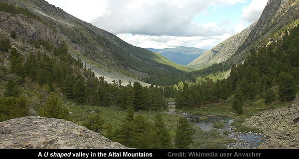
The mainstream mythologists also manufacture a magnificent U-shaped valleys myth.
U-shaped valleys, or glacial troughs, are formed by the process of glaciation.
They are characteristic of mountain glaciation in particular.
They have a characteristic U shape, with steep, straight sides and a flat bottom.
Glaciated valleys are formed when a glacier travels across and down a slope, carving the valley by the action of scouring.
When the ice recedes or thaws, the valley remains, often littered with small boulders that were transported within the ice, called glacial till or glacial erratic.
However, the mainstream has experienced problems selling this “unbelievable” myth because they can’t explain how slow moving glacial ice [which is “quite soft”] carves out U-shaped valleys in bedrock [which is quite hard].
Geologists didn’t always believe that glaciers were responsible for U-shaped valleys and other glacial erosional features.
Ice is quite soft and it was unbelievable to many that it could be responsible for the severe carving of bedrock characteristic of glacial erosion.
https://en.wikipedia.org/wiki/U-shaped_valley
Audience Participation
Readers might like to grab some ice cubes [from the freezer] and experiment by carving their name into a rock [or stone] using [only] ice cubes.

Undeterred, the modern mythologists knocked up a few “models” [aka Digital Etch A Sketches] that were “created to explain the phenomenon” [aka creative confirmation bias].
Progress was made in the 1970s and 1980s on the possible mechanisms of glacial erosion and U-shaped valleys via models proposed by various scientists.
Numerical models have been created to explain the phenomenon of carving U-shaped valleys.
https://en.wikipedia.org/wiki/U-shaped_valley
If you put tomfoolery into a computer, nothing comes out of it but tomfoolery.
But this tomfoolery, having passed through a very expensive machine, is somehow ennobled and no-one dares criticize it.
Pierre Gallois
Computer modelling
http://www.numberwatch.co.uk/computer_modelling.htm
The observational evidence suggests valley glaciers simply [and very slowly] grind down the underlying bedrock [into glacial flour] until a fairly smooth [but scratchy] “pavement” is created.
Glacial striations are scratches or gouges cut into bedrock by glacial abrasion.
These scratches and gouges were first recognized as the result of a moving glacier in the late 18th century when Swiss alpinists first associated them with moving glaciers.
They also noted that if they were visible today that the glaciers must also be receding.
Glacial striations are usually multiple, straight, and parallel, representing the movement of the glacier using rock fragments and sand grains, embedded in the base of the glacier, as cutting tools.
Large amounts of coarse gravel and boulders carried along underneath the glacier provide the abrasive power to cut trough-like glacial grooves.
Finer sediments also in the base of the moving glacier further scour and polish the bedrock surface, forming a glacial pavement.
Ice itself is not a hard enough material to change the shape of rock but because the ice has rock embedded in the basal surface it can effectively abrade the bedrock.

EXTRA BONUS MYTH
The mainstream mythologists merrily maintain that all moraines are “glacially formed”.
A moraine is any glacially formed accumulation of unconsolidated glacial debris (soil and rock) that occurs in currently glaciated and formerly glaciated regions on Earth (i.e. a past glacial maximum), through geomorphological processes.
However, the origins of moraines that are not associated with contemporary glaciers are “debated”.
Moraines can be classified either by origin, location with respect to a glacier or former glacier, or by shape.
The first approach is suitable for moraines associated with contemporary glaciers – but more difficult to apply to old moraines, which are defined by their particular morphology, since their origin is debated.
Some moraine types are known only from ancient glaciers, while medial moraines of valley glaciers are poorly preserved and difficult to distinguish after the retreat or melting of the glacier.
This is hardly surprising because it’s very easy to visually distinguish between:
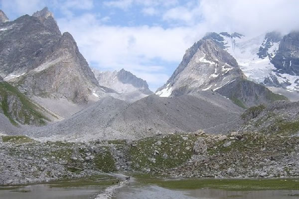
a) Glacial moraines [middle ground] which are primarily composed of glacial flour
and
b) Flood moraines [foreground] which are composed of rocks, boulders, stones and silt.
Hopefully, the mainstream mythologists will abandon their Etch A Sketch and Digital Etch A Sketch toys in the near future [and return to planet Earth].
However, I’m not holding my breath because there is bound to be [somewhere] a Digital Etch A Sketch that can convince the Earth Scientists that pigs can fly.

Pingback: Stratigraphical conundrums | Louis Hissink's Crazy World
The only time “ice” could grind anything is during a small angle earth careen when the icemasys, not being too cemented to the underlying rock, continues to move laterally as a result of the impulsive shock of the sudden careen. This might also explain how Nappes are formed, so the growth rings of an ice cap may instead be where it finally stopped sliding above the land surface.
Imagine the Greenland ice cap’s potential movement if the Earth suddenly careened – I suspect the Greenland mountain ranges might be violently “chopped” off and transported far way to be left as erratics. etc,.
Rolling along….
Interesting article. You should read Velikovsky’s Worlds in Collision (or maybe you have?) for the true origin of the great flood catastrophe and the most likely origin of these [flood] moraines.
Moraines and “flour” are more likely the product of plasma arcing or machining, come to think of it. Ice ages are abrupt and catastrophic accumulations of ice which, counter intuitively, are caused by a massive inrush of protons into water bodies forming ice almost instantaneously. Inrushing protons are electric currents. And always the logical fallacy of arguing the consequent is alive and well in geology.
This may or may not be on topic…
Atlas of the underworld: Slab remnants in the mantle, their sinking history, and a new outlook on lower mantle viscosity
Abstract
Across the entire mantle we interpret 94 positive seismic wave-speed anomalies as subducted lithosphere and associate these slabs with their geological record. We document this as the Atlas of the Underworld, also accessible online at http://www.atlas-of-the-underworld.org, a compilation comprising subduction systems active in the past ~ 300 Myr. — [continues]
http://www.sciencedirect.com/science/article/pii/S0040195117304055