A depressing aspect of some published papers is that they assiduously avoid analysing the raw data.
Instead they plunge headlong into transmogrifying their raw data into Settled Science.
This is regrettable because a simple reality check can provide some valuable insights.
Take, for example, this [potentially] fascinating paper on Sea Surface Temperatures based upon planktonic foraminiferal in cores extracted from the Norwegian continental margin.
By combined use of 210Pb dates, identification of Icelandic tephras of known age, and wiggle matching of 14C radiocarbon dates, exceptional accurate chronologies have been established for two cores (P1003MC and SC) raised from the same location on the Norwegian continental margin and that span the last 8 ka.
They are located directly under the core of the eastern branch of Atlantic water entering the Nordic Seas.
Comparing oxygen isotope measurements on the planktonic foraminiferal species Neogloboquadrina pachyderma (dex) with nearby instrumental time series, suggest that this parameter at this site primarily reflects summer temperature conditions of near surface (c. 50 m) waters.
We argue that this proxy, to some degree, reflects North Atlantic sea surface temperature variability through the Holocene.
A Holocene North Atlantic SST Record and Regional Climate Variability
H.P.Sejrup, Haflidi Haflidason and John T. Andrews
Quaternary Science Reviews – Volume 30, Issues 21–22, October 2011
http://www.sciencedirect.com/science/article/pii/S0277379111002368Foraminifera are members of a phylum or class of amoeboid protists characterized by: streaming granular ectoplasm for catching food and other uses; and commonly an external shell (called a “test”) of diverse forms and materials.
…
Dying planktonic Foraminifera continuously rain down on the sea floor in vast numbers, their mineralized tests preserved as fossils in the accumulating sediment.
…
Because of their diversity, abundance, and complex morphology, fossil foraminiferal assemblages are useful for biostratigraphy, and can accurately give relative dates to sedimentary rocks, as was discovered by Alva C. Ellisor in 1920.
…
Thus, they are very useful in paleoclimatology and paleoceanography.They can be used, as a climate proxy, to reconstruct past climate by examining the stable isotope ratios and trace element content of the shells (tests).
One of the more startling claims made by this paper is that “exceptional accurate chronologies” have been established for the last 8,000 years by using an “Age Model”.
By combined use of 210Pb dates, identification of Icelandic tephras of known age, and wiggle matching of 14C radiocarbon dates, exceptional accurate chronologies have been established for two cores (P1003MC and SC) raised from the same location on the Norwegian continental margin and that span the last 8 ka.
A Holocene North Atlantic SST Record and Regional Climate Variability
H.P.Sejrup, Haflidi Haflidason and John T. Andrews
Quaternary Science Reviews – Volume 30, Issues 21–22, October 2011
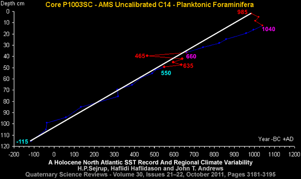
Thankfully, the authors have provided the Uncalibrated Carbon-14 data so that a basic reality check can be performed.
Note: Dates converted from Before Present [1950] to AD/BC
e.g. 1950 – 965BP = 985AD
The interpretation of the wiggles in this raw data depend upon your perspective.
A Gradualist might conclude the radiocarbon dates require calibration.
A Catastrophist might conclude the stratigraphy has been disturbed on numerous occasions.
But both should agree a significant regime change occurred around 3,000 BC [uncalibrated].
Focusing upon the 1st millennium AD reveals:
1) The Arabian Horizon is clearly identifiable between 550AD and 660AD.
2) The Heinsohn Horizon is clearly identifiable at 985AD ± 55 years.
3) Deposition appears to have stopped at the Heinsohn Horizon [985AD ± 55 years].
4) The Carbon-14 regime [temporarily] changed at the Arabian Horizon.
5) Arguably, the Heinsohn Horizon represented a sudden step change reversion to the Carbon-14 regime that existed before the Arabian Horizon.
See: https://malagabay.wordpress.com/2017/03/19/close-encounters-of-the-cometary-kind/
See: https://malagabay.wordpress.com/2015/11/14/heinsohn-and-the-eclipse-record/
Intriguingly, the Age Model in the referenced paper transmogrified the uncalibrated radiocarbon date of the Heinsohn Horizon [985 AD ± 55] into a stunning 1654.3 AD.
The reader is left to decide whether this Age Model produces “exceptional accurate chronologies”.


In the table showing the calibrated C14 data, the top 2cm represent 965AD age?
Deposition of whatever from the present to 2cm represents 1052 years?
Blimey.
The core location: 63º 45′ 44″ N 05º 15′ 19″ E Water depth: 875 metres.
Said to be “located beneath the eastern branch of the Atlantic current”.
Not too far from the Norwegian trench.
The lower 53 cm of the P1003SC core are said to contain debris from the Storegga Slide.
The Storegga Slides are associated “weak geological layers” of which “very little is known”.
Translation:
Weak Geological Layers => Inflating Earth
Storegga Slides => Opening up of the North Atlantic
Norwegian Trench => Draining of the Inland Seas
The Wikipedia entry is simply geological gobbledygook – post-modernist claptrap. The measured uplift of the crust in this region is also not well explained since it cannot be due to the removal of ice sheets and glaciers – rocks of density 1 Kg/m^3 cannot depress rocks of double the density (Isostasic Idiocy). My guess is the bulging is being caused by degassing of CH4 from the mantle caused by some unknown external agent now absent.
The Wikipedia page needs serious Fisking.
My guess for the “unknown external agent”:
See: https://malagabay.wordpress.com/2014/04/12/greenland-the-cape-york-iron-meteorites/
See: https://malagabay.wordpress.com/2014/04/15/deprecating-the-ovifak-iron-meteorites/
See: https://malagabay.wordpress.com/2013/06/04/still-waters-run-deep/
Parent planet with a gravitational field – FM – all planets have a gravity field.
Pingback: The Miocene Mysteries | MalagaBay
Pingback: European Islands of Culture | MalagaBay