

The Zeno Map [claimed to have been drafted in the 1390s] was first published in 1558.
The Zeno map is a map of the North Atlantic first published in 1558 in Venice by Nicolo Zeno, a descendant of Nicolo Zeno, of the Zeno brothers.
The younger Zeno published the map, along with a series of letters, claiming he had discovered them in a storeroom in his family’s home in Venice. According to Zeno, the map and letters date from around the year 1400 and purportedly describe a long voyage made by the Zeno brothers in the 1390s under the direction of a prince named Zichmni.

Amongst the many curiosities found on the Zeno Map is the island of Frisland.
Frisland was shown as a roughly rectangular island with three triangular promontories on its western coast.
https://en.wikipedia.org/wiki/Frisland
“Frisland” appeared on virtually all maps of the North Atlantic from the 1560s through to the 1660s.
https://en.wikipedia.org/wiki/Zeno_map
Its existence was given currency in manuscript maps of the 1560s by the Maggiolo family of Genoa and was accepted by Mercator and Jodocus Hondius.
Some early maps by Willem Blaeu, such as his 1617 map of Europe, omit it, but it reappears on his 1630 world map as one of many islands shown off the eastern coast of Labrador which was then believed to extend to within a few hundred miles of Scotland.
It also appeared on a 1652 world map by Visscher, largely copied from that of Blaeu.


The mainstream classify the Zeno Map as a “hoax” populated with “phantom islands”.
Most historians regard the map and accompanying narrative as a hoax, perpetrated by the younger Zeno to make a retroactive claim for Venice as having discovered the New World before Christopher Columbus.
The evidence against the authenticity of the map is based largely on the appearance of many phantom islands in the North Atlantic and off the coast of Iceland.
One of these non-existent islands was Frisland, where the Zeno brothers allegedly spent some time.
https://en.wikipedia.org/wiki/Zeno_map


However, the Zeno Map has some [very remarkable] redeeming features.
Firstly, the Zeno Map includes a breathtakingly accurate depiction of South Greenland which is very difficult to explain away when compared [for example] with the Mercator Arctic Map of 1606 [see above].

If the Zeno Map of Greenland is taken at face value then it suggests the dramatic geological upheavals in Eastern Greenland occurred after the Zeno Map was drafted.
The Geology of East Greenland – James Cresswell
Click to access Geology%20of%20East%20Greenland%20article%20by%20James.pdf
Traill Island is a coastal island located in the desolate region of Eastern Greenland on the northern side of King Oscar Fjord.
…
The highest point of the island, a 1,884 metres (6,181 feet) high unnamed peak, is one of the ultra-prominent summits of Greenland.https://en.wikipedia.org/wiki/Traill_Island


The second redeeming feature of the Zeno Map is that it neatly dovetails with the narrative of Atlantic Expansion that’s been well documented by cartographers since [at least] 1606.
See: https://malagabay.wordpress.com/2017/02/04/iceland-goes-south/
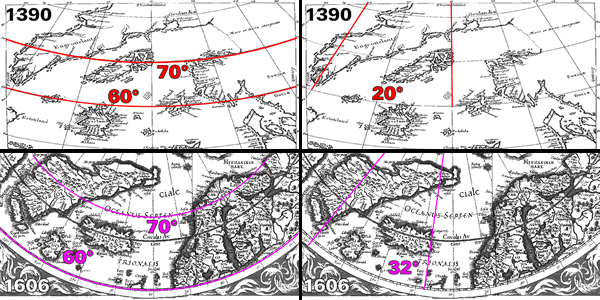
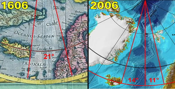
If the cartographic evidence is taken at face value [including the Zeno Map] then it becomes apparent that the “phantom island” of Frisland would have travelled in an Easterly direction [due to the documented Atlantic Expansion] and should be currently located to the North West of Ireland.

Following this line of evidence the independent observer encounters the islet of Rockall, Hasselwood Rock, Helen’s Reef and the “elevated seabed” known as the Rockall Bank.
The islet of Rockall is one of the few pinnacles of the surrounding Helen’s Reef.
It is located 301.3 km, or 162.7 nmi west of the island of Soay, St Kilda, Scotland, and 423.2 kilometres (263.0 miles; 228.5 nautical miles) northwest of Tory Island, County Donegal, Ireland.
…
The surrounding elevated seabed is called the Rockall Bank, lying directly south from an area known as the Rockall Plateau.It is separated from the Outer Hebrides by the Rockall Trough, itself located within the Rockall Basin (also known as the “Hatton Rockall Basin”).
…
Rockall is made of a type of peralkaline granite that is relatively rich in sodium and potassium.Within this granite are darker bands richer in iron because they contain the pyroxene mineral aegirine and the amphibole mineral riebeckite. The dark bands are a type of granite that geologists have named “rockallite”, although use of this term is now discouraged.
In 1975, a mineral new to science was discovered on Rockall.
The mineral is called bazirite, (chemical composition BaZrSi3O9), named after the elements barium and zirconium.
Rockall forms part of the deeply eroded Rockall Igneous Centre that was formed as part of the North Atlantic Igneous Province, approximately 55 million years ago, when the ancient continent of Laurasia was split apart by plate tectonics.
Greenland and Europe separated and the northeast Atlantic Ocean was formed between them.
https://en.wikipedia.org/wiki/Rockall
Helen’s Reef is a series of skerries in the North Atlantic, 1.2 miles (2 km) to the north-east of the larger islet of Rockall and outcrop of Hasselwood Rock, within the United Kingdom’s exclusive economic zone.
…
The skerries are covered at high tide or in rough seas, and are often only visible as breaking waves.

And there, beneath the waves, lies the “phantom island” of Frisland.
The islet of Rockall is actually a minuscule part of vast plateau of submerged continent.
Bathymetric Map of Rockall and Helen’s Reef – Marine Scotland

Therefore, the independent observer is left to decide whether “Greenland and Europe separated”:
a) About 55 million years ago according to mainstream theory [aka Geologic Time].
or
b) About 1,000 years ago according to the cartographic evidence.
Personally, I have far more faith in the cartographers.

So if we reverse the expansion, and drop the sea level so Friesland is above water, then would England join up with France? Ie the channel would disappear?
My guess is that the “Dover Strait” was a late breakthrough.
But your guess is as good as mine when it comes to being more precise…
Pingback: The Frisland Finesse: A Tale of Two Islands | MalagaBay
This may be of interest: ‘Britain cut off from Europe by ‘super-river’ as little as 30,000 years ago’
A prehistoric “super river” periodically cut Britain off from France thousands of years before the formation of the English Channel, scientists have established.
Researchers have found sediment on the ocean floor off France which originated in the north of the channel which must have been transported by the river originally fed by the Thames and the Rhine.
http://www.telegraph.co.uk/news/science/science-news/6672515/Britain-cut-off-from-Europe-by-super-river-as-little-as-30000-years-ago.html
Thanks Oldbrew… it’s very relevant. Tim
Pingback: Shaping Scotland In Two Shakes | MalagaBay
Pingback: Close To The Edge | MalagaBay
Pingback: Ravenna Revisited: The Heinsohn Horizon | MalagaBay