

The history of Iceland includes a curious Riches to Rags sub-plot which [beginning around the 16th century] transforms Iceland into “one of the poorest countries in Europe”.
The Middle Ages
The Icelandic Commonwealth lasted until the 13th century, when the political system devised by the original settlers proved unable to cope with the increasing power of Icelandic chieftains. The internal struggles and civil strife of the Age of the Sturlungs led to the signing of the Old Covenant in 1262, which ended the Commonwealth and brought Iceland under the Norwegian crown. Possession of Iceland passed from the Norwegian Empire to the Kalmar Union in 1415, when the kingdoms of Norway, Denmark and Sweden were united.After the break-up of the union in 1523, it remained a Norwegian dependency, as a part of Denmark–Norway.
In the ensuing centuries, Iceland became one of the poorest countries in Europe.
Infertile soil, volcanic eruptions, deforestation and an unforgiving climate made for harsh life in a society where subsistence depended almost entirely on agriculture.
This Riches to Rags storyline is well illustrated by the transformation of Iceland’s [stand-out] fiery volcanoes into grumbling ice caps.
The Carta marina is the common short form of what is more fully titled Carta marina et descriptio septentrionalium terrarum (Latin “Marine map and description of the Northern lands”). Swedish ecclesiastic Olaus Magnus created the map, which was published in 1539.
https://en.wikipedia.org/wiki/Carta_marina


Iceland’s curious Fire to Ice transformation has been exceedingly well documented by cartographers for nearly 500 years primarily because [until 1884] Iceland was located at the point where the Arctic Circle crossed the Prime Meridian.
The Arctic Circle is the most northerly of the five major circles of latitude that mark maps of the Earth.
…
The position of the Arctic Circle is not fixed; as of 3 February 2017, it runs 66°33′46.6″ north of the Equator.
…
Consequently, the Arctic Circle is currently drifting northwards at a speed of about 15 m (49 ft) per year.https://en.wikipedia.org/wiki/Arctic_Circle
A prime meridian is a meridian (a line of longitude) in a geographical coordinate system at which longitude is defined to be 0°.
…
Ptolemy used as his basis the “Fortunate Isles”, a group of islands in the Atlantic which are usually associated with the Canary Islands (13° to 18°W), although his maps correspond more closely to the Cape Verde islands (22° to 25° W)… Ptolemy’s Geographia was first printed with maps at Bologna in 1477, and many early globes in the 16th century followed his lead.
…
The Tordesillas line was eventually settled at 370 leagues west of Cape Verde. This is shown in Diogo Ribeiro’s 1529 map.
…
In 1541, Mercator produced his famous 41 cm terrestrial globe and drew his prime meridian precisely through Fuertaventura (14°1’W) in the Canaries.His later maps used the Azores, following the magnetic hypothesis.
But by the time that Ortelius produced the first modern atlas in 1570, other islands such as Cape Verde were coming into use.
In his atlas longitudes were counted from 0° to 360°, not 180°W to 180°E as is usual today.
This practice was followed by navigators well into the 18th century.
In 1634, Cardinal Richelieu used the westernmost island of the Canaries, Ferro, 19° 55′ west of Paris, as the choice of meridian. The geographer Delisle decided to round this off to 20°, so that it simply became the meridian of Paris disguised.
…
In 1884, at the International Meridian Conference in Washington, D.C., 22 countries voted to adopt the Greenwich meridian as the prime meridian of the world.
Following the introduction of the Greenwich Meridian [1884] the accolade for the most memorable cartographic location in Iceland passed to the small island of Grímsey located at the intersection of the Arctic Circle with the 18° West line of longitude.
Coordinates: 66°33′N 18°00′W
Grímsey is a small Icelandic island, 40 kilometres (25 mi) off the north coast of the main island of Iceland and straddling the Arctic Circle.
https://en.wikipedia.org/wiki/Gr%C3%ADmsey


Grímsey has been [generally] cartographically stable since the introduction of the Greenwich Meridian.


But between 1645 and 1761 Grímsey Went South by about one degree.


And [overall] the cartographic evidence suggests Iceland Went South by [about] one and a half degrees between 1606 and 1906.

This anomalous movement could easily be dismissed as an observational error were it not for the evidence that in 1606:
1) Iceland was at the intersection of the Arctic Circle and the Prime Meridian.
2) The measurement of latitude was very precise.
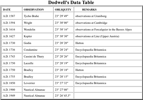
The Obliquity Of The Ecliptic – George F. Dodwell
http://www.setterfield.org/Dodwell/Dodwell_data.html
This southerly movement of Iceland [by about one and a half degrees in 300 years] clearly doesn’t sit well with the narrative of Iceland’s fiery volcanoes being transformed into grumbling ice caps.
Therefore, it seems likely Iceland’s cooling climate was primarily caused by other factors.

The evidence suggests these other factors included a flood of very cold Arctic water.

Evidence of rapid sea floor expansion [by about 4 degrees of longitude] between Iceland and Norway indicates:
a) Very cold seawater from the Arctic Oceans began to flood into the North Atlantic.
b) Greenland was realigned into a more pronounced North-South alignment.
See: https://malagabay.wordpress.com/2013/05/28/the-inflating-earth/

The evidence from the Greenland GISP2 Ice Core suggests this period of very rapid sea floor expansion began in 1647.
The “excess chloride” record from the Greenland GISP2 Ice Core provides two startling outlier observations that echo the underlying 700 year rhythm of the Lawler Events.
The first outlier date of 953 AD suggests the Heinsohn Horizon was a Lawler Event that was followed by another Lawler Event [694 years later] in 1647 AD.
Excess chloride periodicities do not, however, appear to reflect just H2SO4-induced volatilization of HCl as was suggested from a comparison of their trends but perhaps also reflect marine chloride produced under other conditions conducive to fractionation of sea-salt aerosols (e.g., evaporation, decrease in storminess).
Greenland ice core “signal” characteristics: An expanded view of climate change
P. A. Mayewski, L. D. Meeker, M. C. Morrison, M. S. Twickler, S. I. Whitlow, K. K. Ferland, D. A. Meese, M. R. Legrand, J. P. Steffensen
Journal of Geophysical Research, Vol 98, No D7 : 12,839-12,847, 20 July 1993See: https://malagabay.wordpress.com/2016/02/09/lawler-events-and-the-heinsohn-horizon/

The evidence from the Old Japanese Cedar Tree clearly confirms a significant drop in Northern Hemisphere temperatures began in [about] 1650 [aka The Little Ice Age] and these events may well have been triggered by a catastrophic impact [presumably in the Arctic basin].
The Old Japanese Cedar D/H Ratio trace includes a signature pattern [roughly between 1650 and 1750] that has been associated with the catastrophic division of a comet.
See: https://malagabay.wordpress.com/2015/11/24/the-little-ice-age/


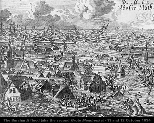
However, it’s worth noting, the devastating North Sea storm tide [aka tsunami] of 11/12 October 1634 may more accurately date this presumed impact in the Arctic basin.
The mainstream mantra of “insufficient maintenance” takes a step into the surreal when it comes to the Burchardi flood of 1634 which caused “thousands of deaths”.
See: https://malagabay.wordpress.com/2016/02/15/beware-academics-bearing-storms/
Either way, it seems very likely the mainstream concept of Geologic Time is seriously flawed.

Tim,
The minor expansion in the north Atlantic could be the sinking of Atlantis story when survivors on both sides maintained their ancestors lived t’other side. This then has to predate Greek/Roman history unless the Timaeous & Critias is also a fabrication of our post HH survivors.
Impact – I would not attribute that to a bolide, but a newly located plasma current entry/exit point as the Earth careened to a new celestial orientation during the physical stresses of the situation at the time.
The 1634 events could also be linked to the Australian Aboriginal tale of their ancestors being mass killed by the Southern Aurora in Victoria. This might like with Ted Bryants Tsunami theory for Eastern Oz, and the extinction of the NZ Moa.
Given the recent emphasis on ‘Fake News”, I’m no longer prepared to accept any ‘official’ version of history. They are not lying either, but simply demonstrating a pervasive gullibility and robotic thinking process, if they are aware of their thinking processes in the first place.
link with Bryant’s etc
Louis,
I’m working on a follow-up story which may help clarify a few thoughts.
Tim
See: https://malagabay.wordpress.com/2014/04/12/greenland-the-cape-york-iron-meteorites/
See: https://malagabay.wordpress.com/2014/04/15/deprecating-the-ovifak-iron-meteorites/
Re the LIA: it was the Maunder Minimum that started around 1650, not the LIA. The MM was a period of very low solar activity, but whether that itself could cause lower temperatures is still debated as we all know.
Wikipedia says ‘The onset of the Little Ice Age also occurred well before the beginning of the Maunder minimum.’
http://en.wikipedia.org/wiki/Maunder_Minimum
Tim,
Ok, I can see where you are heading to. Clark Whelton and I agree the Comet of Justinian might be Venus, but Mars needs to be looked at as well. The documented meteorites per your links, on ice, become interesting, especially the Cape York one. Sitting on ice?
I will go into stall mode. 🙂
Pingback: Finding Frisland | MalagaBay
Any impact from any celestial object would always be preceded by a huge electrical discharge. I also think that gravity is modified by electrical charge.
All “scientific” clocks and rulers are broken and give false data.
Amazingly every bolide that has ended up in the Earth’s atmosphere has collided at a glancing angle – and burnt up in the thinnest of atmosphere by friction. Electrical short circuit more likely. Bolide impact is due to our obsession with billiard-ball mechanics, in a gravity only universe.So if a hammer is your only tool. ,,,,,,,
I don’t think the human fear of comets and meteorites is from impacts, but from the massive electrical short circuits as the cosmic body interrupts the magneto/plasma sphere of the Earth causing massive currents from the sun to flow into new paths.
Gravity is indeed modified by electric charge and http://breakthroughinenergy.com is another take on the topic by an electrical engineer.
I agree.
My posts have been terse because of this infernal handheld “device” I am lately forced to use. But it works nicely to hamper communication.
Pingback: Shaping Scotland In Two Shakes | MalagaBay
Pingback: Comet Halley Clock | MalagaBay
1634 is very interesting given what was happening – and not happening – in the 30 Years War at that time.
Germany was more dramatically depopulated from 1618 to 1648 than it was from 1914 to 1945.
Do we find any testimony to comets in the skies or mysterious “plagues” approximating to cyanogen poisoning from comet fly-byes during that time?
It seems unlikely that Venus was responsible for the Justinian/King Arthur comet flyby. Velikovsky provides celestial mechanisms for the eruption of Venus, hundreds of years of regular fly-byes and close encounters with it and then direct interactions between Mars and Venus.
However, Jupiter certainly gave birth to other comets in the thousands of years since those events. Vsyekhsviatskii’s great work in Kiev from the 1930s at least into the 1960s clearly documents the almost certainty that Jupiter is the main womb of Solar System comets – not the entirely fictional and non-existent Oort Cloud.
The nearest cyanogen poisoning possibility [I’ve found so far] is 1545:
See: https://malagabay.wordpress.com/2017/09/26/the-atomic-comet-death-in-the-clouds/
I’m researching another cyanogen poisoning possibility…
So watch this space…
I hope to pull a posting together in the next few weeks.
A point about 1600’s and the heavy human depopulation, bubonic plague in Europe was a major cause. An extract: “The Order of St John relied on quarantine and a vigilant Board of Health to safeguard the population. A period of uncertainty or denial would be followed by panic when those who could, fled to the countryside. The rest barred themselves inside their homes. The infected were removed to the Lazzaretto, built on Manoel Island for that specific purpose during the reign of Grand Master Jean-Paul de Lascaris Castellar in 1643. Fort Manoel was also used to detain those who had come into contact with the sick.” And “there had been four outbreaks of plague – in 1592-1593, 1623, 1655 and 1676.” The initials were mainly foreigners from Europe.
Re quote: “Either way, it seems very likely the mainstream concept of Geologic Time is seriously flawed.”, suggest add ‘very’ to seriously. Local geo/archaeo anomalies speculatively dated to 1.5 -5 million yrs ago, appear to have occurred 5200 yrs ago, with substantial evidence from an increasing load of proxies. (which prove Dodwell right).
Re “Consequently, the Arctic Circle is currently drifting northwards at a speed of about 15 m (49 ft) per year.” Axial tilt of the earth is decreasing (wiki), meaning arctic circle will occur further north.
RE: ‘The Old Japanese Cedar D/H Ratio trace includes a signature pattern [roughly between 1650 and 1750] that has been associated with the catastrophic division of a comet.’
The Maunder Minimum started around 1650, lasting about 70 years.
http://en.wikipedia.org/wiki/Maunder_Minimum
The Korean Choson annals document many unusual phenomena.
http://abob.libs.uga.edu/bobk/korea/
Intro: “During the 17th century, there was a long-term drop in overall global temperatures, which led to a sharp reduction in agricultural production. This, in turn, brought about widespread famine and epidemics and had major social and political repercussions. The extended abnormal temperature drop of this period has been recognized by natural scientists, who have called this the “Little Ice Age.” However, little research has been done on the cause or causes of this temperature drop beyond John A. Eddy’s work on the decline in sunspot activity. After I came across the 17th-Century Crisis theory in the works of Western scholars, I felt that the Annals of the Chosôn Dynasty (Chosôn wangjo sillok in Korean; hereinafter referred to as the “Annals”) could potentially be a valuable source of reliable information for this time period. The scribes who compiled the Annals were faithful and meticulous in recording all natural and unusual (often seen as supernatural) phenomena, in accordance with the distinctive Confucian view of nature. Because of this, I believed that these records could provide much valuable insight into phenomena that attended and perhaps led to the Little Ice Age. After ten years of research, I can demonstrate that my initial expectations were correct”.
The author stresses “In my study, I did not include records of solar eclipses, lunar eclipses, and unusual movements of the planets,1) since they cannot really be considered “abnormal” natural phenomena according to today’s modern standards.”
Pingback: Iceland’s Ice | MalagaBay
Pingback: Alaskan Muck: Anaximander’s Cake | MalagaBay
Pingback: Cape Bojador and The Inflating Earth | MalagaBay
Pingback: Ptolemy’s Paradigm: Antarctic Alignment | MalagaBay
Pingback: Ptolemy’s Paradigm: Aftermath | MalagaBay