

For Frank Hibben code breaking was a piece of cake.
Alaskan Muck Layers
Frank Hibben knew the secret that unlocks the Alaskan Muck Mystery.
The total of these evidences indicates the alternate and intermittent periods of violent erosion such as would dismember animal remains and splinter trees, interspersed with other periods of comparative quiescence so as to allow the growth of “forests” and peat bogs in the same area.
Archaeological Aspects of the Alaska Muck Deposits
Frank C Hibben – 1941
New Mexico Anthropologist, Volume 5, Number 4
https://digitalrepository.unm.edu/cgi/viewcontent.cgi?article=1189&context=nm_anthropologist

Episodes of “violent erosion” interspersed with periods of “comparative quiescence” provides the key to understanding the oscillations that are so very visible in the Greenland ice cores during the turbulent 500 years beginning around 900 CE at the Heinsohn Horizon and ending with the Hecker Horizon at 1400 CE.
See: https://malagabay.wordpress.com/2019/07/17/alaskan-muck-when-then-was/
Note #1
There are very striking structural similarities between the 3,000 metre GRIP ice core and the 35 metre ice-rich permafrost deposits of Bolshoy Lyakhovsky Island that show sure signs of “violent erosion” interspersed with periods of “comparative quiescence”.
https://epic.awi.de/id/eprint/9644/1/And2003h.pdf
https://en.wikipedia.org/wiki/New_Siberian_Islands
https://en.wikipedia.org/wiki/Weichselian
The Saale glaciation or Saale Glaciation, sometimes referred to as the Saalian glaciation, Saale cold period, Saale complex covers the middle of the three large glaciations in Northern Europe and the northern parts of Eastern, Central and Western Europe by the Scandinavian Inland Ice Sheet between the older Elster glaciation and the younger Weichselian glaciation.
…
It succeeded the Holstein interglacial and was followed by the Eemian interglacial.The Saale complex is currently estimated, depending on the source, as existing from around 300,000 to 130,000 years ago or 347,000 to 128,000 years ago (duration: around 219,000 years), roughly contemporaneous with the glaciation of the Riss Glacial in the Alpine region.
…
The Saale Glaciation occurred at around the same time as the Wolstonian Stage in the British Isles and the Illinoian Stage in North America.In 1910, the name for “Saale glaciation” was given by German geologists Jacob Stoller and Konrad Keilhack.
https://en.wikipedia.org/wiki/Saale_glaciation
Note #2
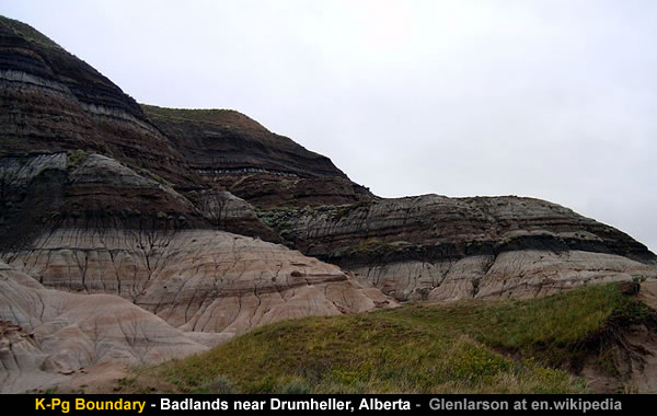
In the above [mainstream] version of history the Saalian Ice Complex appears to represent the Heinsohn Horizon.But in other [mainstream] versions of history the Heinsohn Horizon probably represents the Cretaceous–Paleogene (K–Pg) Boundary.
The K–Pg boundary marks the end of the Cretaceous Period, the last period of the Mesozoic Era, and marks the beginning of the Paleogene Period, the first period of the Cenozoic Era. Its age is usually estimated at around 66 Ma (million years ago), with radiometric dating yielding a more precise age of 66.043 ± 0.011 Ma.


A pattern of “violent erosion” followed by periods of “comparative quiescence” is very suggestive of a series of close encounters with a Velikovskian bituminous comet.
The origin of the coal beds is still far from being satisfactorily explained.
Earth In Upheaval – Immanuel Velikovsky – 1955
Amazon US: https://www.amazon.com/dp/1906833125Many people think that the origin of coal is completely understood.
This is not the case.
What has happened is what happens only too often in science:
An unsatisfactory explanation is accepted because no more satisfactory explanation turns up over a long period of time.The Deep Hot Biosphere – Thomas Gold – 1999
https://books.google.es/books?id=b17dBwAAQBAJ&pg=PA87&lpg=PA87
https://archive.org/details/atlantisantedilu00donnuoft/page/31
Forests burned, a hurricane uprooted them, and a tidal wave or succession of tidal waves coming from the sea fell upon the charred and splintered trees and swept them into great heaps, tossed by billows, and covered them with marine sand, pebbles and shells, and weeds and fishes; another tide deposited on top of the sand more carbonized logs, threw them in other heaps, and again covered them with marine sediment.
The heated ground metamorphosed the charred wood into coal, and if the wood or the ground where it was buried was drenched in a bituminous outpouring, bituminous coal was formed.
Wet leaves sometimes survived the forest fires and, swept into the same heaps of logs and sand, left their design on the coal.
Thus it is that seams of coal are covered with marine sediment; for that reason also a seam may bifurcate and have marine deposits between its branches.
Earth In Upheaval – Immanuel Velikovsky – 1955
Amazon UK: https://www.amazon.co.uk/dp/1906833125
The “aromatic” benzene rings indicate comets [such as Velikovsky’s Comet Venus] should be sources of carbon and hydrogen gases.
Let’s see.
Comets are renowned for appearing carbonised e.g. “blacker than coal”.
Comets [and burning hydrocarbons] are noted for their characteristic carbon Swan Bands.
Comets are renowned for producing lots of Hydrogen.
Cometary grains are renowned for their ubiquitous “dark polyaromatic hydrocarbons”.
And the crust of Comet Churyumov–Gerasimenko contains “polyaromatic organic solids”.
See: https://malagabay.wordpress.com/2017/09/22/the-atomic-comet-a-velikovsky-vindication/
Lignite, or brown coal, the lowest rank of coal, most harmful to health, used almost exclusively as fuel for electric power generation.
…
Sub-bituminous coal, whose properties range between those of lignite and those of bituminous coal, is used primarily as fuel for steam-electric power generation.
…
Bituminous coal, a dense sedimentary rock, usually black, but sometimes dark brown, often with well-defined bands of bright and dull material.
…
Anthracite, the highest rank of coal is a harder, glossy black coal used primarily for residential and commercial space heating.
…
Around 10% of coal is ash: coal ash is hazardous and toxic to human beings and some other living things.Coal ash contains the radioactive elements uranium and thorium.
https://en.wikipedia.org/wiki/Coal#Damage_to_human_health
75° 05′ 14″ N 148° 27′ 30″ E
New Siberia Island is noted for abundant upright tree trunks, logs, leaf prints, and other plant debris that occur within sediments that are exposed along sea cliffs and within the uplands of the Derevyannye Hills along its southern coast.
Because of the abundance of exposed coalified logs and upright trunks, early explorers and paleobotanists referred to the Derevyannye Hills as either the “Wood Mountains”, “Wood Hills”, or “Tree Mountain”.
At one time, the highly folded layers of sand, silt, mud, clay, and brown coal containing these coalified tree fossils were once thought to have accumulated during either the Miocene or Eocene Epoch.
These sediments and the fossil trunks and logs, which they contain, are now known to date to the Late Cretaceous Period (Turonian Stage).
Baron Von Toll, Dr. Klubov and others, Dr. Dorofeev and others, and other publications all demonstrate that the claims by some authors, i.e. Mr. Southall, that the “Wood Hills” of New Siberia Island are either partially or completely “formed of driftwood” are completely erroneous.
https://en.wikipedia.org/wiki/New_Siberia
The Ivory Islands in The Arctic Ocean – Rev. D. Gath Whitley
Hedenstrőm and Sannikoff thoroughly examined the large island of New Siberia, which contained wonders as surprising as Kotelnoi, and so enormous were the quantities of mammoths’ tusks on it, that in 1809 Sannikoff brought away 10,000 lbs. of fossil ivory from New Siberia alone.
It was on this dreary and icy island that Hedenstrőm made another remarkable discovery.
He found in this desolate wilderness, the shores of which are blocked by ice for the greater part of the year, the remains of enormous petrified forests.
The trunks of the trees in these ruins of ancient forests were partly standing upright and partly lying horizontally buried in the frozen soil.
Their extent was very great, and he described them as follows : –
” On the southern coast of New Siberia are found the remarkable wood hills (i.e., the remains of the forests).
They are 30 fathoms high, and consist of horizontal strata of sandstone, alternating with strata of bituminous beams or trunks of trees.
On ascending these hills fossilized charcoal is everywhere met, covered apparently with ashes, but on closer examination this ash is also found to be a petrifaction and so hard that it can scarcely be scraped off with a knife.
On the summit another curiosity is found, namely, a long row of beams, resembling the former, but fixed perpendicularly in the sandstone.
The ends, which project from 7 to 10 inches, are for the greater part broken.
The whole has the appearance of a ruinous dyke.”
These ” wood hills ” rise to such a height that they were visible from a distance of nearly 80 miles : similar buried forests are found in the island of Kotelnoi.
The Ivory Islands in the Arctic Ocean – Rev D Gath Whitley
Journal of the Transactions of the Victoria Institute – Volume XLII – 1910
https://archive.org/details/journaloftransac421910vict/page/43PDF Version: https://biblicalstudies.org.uk/pdf/jtvi/1910_035.pdf


However, it’s a challenge identifying the number of “violent” episodes:
1) Each “violent” episode may involve some sloshing about of tsunami debris.
2) The periods of “quiescence” may involve several sediment layers.
3) The Mastodon’s “trend of declining age at maturation” is consistent with a declining orbital period during the terminal phase of a cometary cascade.
Fossil evidence indicates that mastodons probably disappeared from North America about 10,500 years ago as part of a mass extinction of most of the Pleistocene megafauna that is widely believed to have been a result of human hunting pressure.
…
Analysis of tusks of mastodons from the American Great Lakes region over a span of several thousand years prior to their extinction in the area shows a trend of declining age at maturation; this is contrary to what one would expect if they were experiencing stresses from an unfavorable environment, but is consistent with a reduction in intraspecific competition that would result from a population being reduced by human hunting.https://en.wikipedia.org/wiki/Mastodon#Extinction
Radiocarbon dates from 9,600 to 5,300 years ago have been found for some mastodon remains. It must be conceded that they may possibly have survived in North America until a much later date than this.
The Mastodons of New York
Earth’s Shifting Crust: A Key to Some Basic Problems of Earth Science
Charles Hutchins Hapgood – 1958 – Pantheon Books
https://archive.org/details/eathsshiftingcru033562mbp/page/n273
On the other hand:
It’s also a challenge guessing the number of years needed to grow a forest.

Somewhere in the range of 40-70 years may [or may not] be a reasonable guess that implies there were [something like] 7 to 12 “violent” episodes between 900 and 1400 CE.

At this point it’s helpful to look again at the layered lignite mines in Europe.
Balkan Lignite Layers
A lignite mine in Romania reveals more information about the “violent” episodes followed by periods of “comparative quiescence”.
○ The first “violent” episode is associated with the thickest layer of lignite.
○ Subsequent layers of lignite suggest fairly uniform periods of “quiescence”.
○ The 40-70 year guesstimate for periods of “quiescence” appears reasonable.○ The first layer of lignite is covered by the thickest layer of loess.
○ Subsequent layers of loess become thinner and thinner.


Balkan Endemic Nephropathy.
Lignite introduces a poisoned wells connection back to 1349.
Third parties finally claimed that the Jews had poisoned all the wells to exterminate the Christian world.
Das Buch der Natur – Konrad von Megenberg – 1349
Modern German edition – H Schulz – 1897
See: https://malagabay.wordpress.com/2019/06/10/hecker-horizon-konrad-von-megenberg/

Geologists acknowledge lignites releases “toxic organic substances” into Balkan groundwater that contaminates village wells in areas associated with Balkan Endemic Nephropathy.
See: https://malagabay.wordpress.com/2019/06/19/alaskan-muck-the-missing-trees/
Seam or bed of Pliocene lignite from a mine in the Balkan endemic nephropathy (BEN) area of Romania.
Rainwater falling onto the surface penetrates into the ground, becoming ground water, and leaches toxic organic substances from this coal.
The ground water continues to BEN villages in the valleys below carrying toxic organic substances, feeding shallow wells and springs used by villagers as a primary drinking water supply.
USGS – Pliocene Lignite Coal from BEN Village
https://www.usgs.gov/media/images/pliocene-lignite-coal-ben-village

However, other experts aren’t certain what causes Balkan Endemic Nephropathy.
Balkan endemic nephropathy is a form of interstitial nephritis.
It was first identified in the 1920s among several small, discrete communities along the Danube River and its major tributaries, in the modern countries of Croatia, Bosnia and Herzegovina, Serbia, Romania, and Bulgaria.
The disease primarily affects people age 30 to 60 years of age.
People moving to endemic areas do not develop the condition until living there for 15 years.It can cause kidney failure (end-stage renal disease, or ESRD) forcing a patient to start dialysis or receive a kidney transplant [or, to die – Malagabay edit].
…
At least 25,000 individuals are known to have the disease.
…
Other names: Danubian endemic familial nephropathy
…
The cause of DEFN is not certain …https://en.wikipedia.org/wiki/Balkan_endemic_nephropathy


Image that!
Public health professionals being uncertain about the “cause”.
https://en.wikipedia.org/wiki/Romani_people
Having personally witnessed the European Apartheid System in full flow in Eastern Europe during the 1990s it’s very understandable that European Civilization prefers to manage a sanitised version of 2nd millennium history.
See: https://malagabay.wordpress.com/2016/07/02/catastrophic-english-r-is-for-roma/

European Loess Layers
Similarly, loess covering the lignite introduces a connection back to 1349.
Before 1350, there were about 170,000 settlements in Germany, and this was reduced by nearly 40,000 by 1450.
https://en.wikipedia.org/wiki/Black_Death#Death_toll
Thirdly, sand and dust are often thrown out of the earth in large quantities during the earthquake, so that an entire village can be buried.
Das Buch der Natur – Konrad von Megenberg – 1349
Modern German edition – H Schulz – 1897
https://archive.org/details/bub_gb_oj3sQ5ISS3wC/page/n97See: https://malagabay.wordpress.com/2019/06/10/hecker-horizon-konrad-von-megenberg/

The loess covering extends eastwards into Ukraine and Russia.

The extended eastern coverage is curiously coincidental with the burned house horizon where settlements were burned every 75-80 years.
Cucuteni-Trypillian settlements were completely burned every 75–80 years, leaving behind successive layers consisting mostly of large amounts of rubble from the collapsed wattle-and-daub walls.
This rubble was mostly ceramic material that had been created as the raw clay used in the daub of the walls became vitrified from the intense heat that would have turned it a bright orange color during the conflagration that destroyed the buildings, much the same way that raw clay objects are turned into ceramic products during the firing process in a kiln.
Moreover, the sheer amount of fired-clay rubble found within every house of a settlement indicates that a fire of enormous intensity would have raged through the entire community to have created the volume of material found.
https://en.wikipedia.org/wiki/Burned_house_horizon
See: https://malagabay.wordpress.com/2019/01/21/the-hecker-horizon-coincidental-catastrophe/
See: https://malagabay.wordpress.com/2016/04/03/burned-house-syndrome/


This suggests there were 6 or 7 periods of “quiescence” lasting [roughly] 75-80 years each.
If Eilmer had seen Halley’s comet seventy-six years earlier in 989, he could have been born about 984, making him about five or six years old when he first saw the comet, old enough to remember it.
However the periodicity of comets was probably unknown in Eilmer’s time, and so his remark “It is long since I saw you” could have referred to a different, later comet.
https://en.wikipedia.org/wiki/Eilmer
The 607 CE Earthly encounter with Comet Halley appears to have triggered the catastrophic plunge in temperatures that only began to recover after the Arabian Horizon in 637 CE.
The 760 CE Earthly encounter with Comet Halley appears to be associated with the catastrophic deposition of sand and gravel.
And the 912 CE Earthly encounter with Comet Halley appears to be closely associated with the catastrophic Heinsohn Horizon in 914 CE.
…
The Transit of Venus in 912 CE also suggests 912 CE was a very powerful alignment and that a Halley-Venus-Earth alignment could have emulated the conditions associated with Immanuel Velikovsky’s “Comet Venus”….See: https://malagabay.wordpress.com/2017/03/19/close-encounters-of-the-cometary-kind/
See: https://malagabay.wordpress.com/2017/09/26/the-atomic-comet-death-in-the-clouds/


Either way:
The Black Death was a “violent” episode that involves much more than plague.
See: https://malagabay.wordpress.com/2019/01/21/the-hecker-horizon-coincidental-catastrophe/

And:
The Renaissance was a “quiescence” that didn’t end violently.
The Renaissance is a period in European history, covering the span between the 14th and 17th centuries and marking the transition from the Middle Ages to modernity.


Muck, mammoths, mastodons, Hibben, Heinsohn, Hecker, Velikovsky, Venus and Halley’s recurring killer… a layer cake that slices the Earth. In the Burned House horizon they enjoy it with fries. Well done, Tim!
Gunnar Heinsohn’s revision of 1st millennium AD chronology was made possible by his insight that Antiquity, Late Antiquity and the Early Middle Ages were contemporary aspects of the same period of Roman history. Heinsohn also came to realize that the fall of Rome was caused by two natural catastrophes. Rome was weakened by the first catastrophe, the Antonine fires and plague during the reign of Marcus Aurelius. Rome was destroyed by the second catastrophe, which buried large areas of the empire and the city of Rome in “dark earth” circa 930 AD. The two catastrophes were separated by some 50 or 60 years. I’m wondering if the “Burned House Horizon” might be evidence of the Antonine Fires. Do we know for sure that consecutive passages of Halley’s comet have always been separated by the same number of years we observe today? Could the comet’s path and periodicity have been altered by close approaches to Earth?
Do we know for sure that consecutive passages of Halley’s comet have always been separated by the same number of years we observe today?
NO
Do we know for sure comet Halley existed before 1531?
NO
Could a comet’s path and periodicity have been altered by close approaches to Earth?
YES
Could the Earth’s path and periodicity have been altered by the close approach of a comet?
That’s an interesting question!
Pingback: Alaskan Muck: The Canning River Region | MalagaBay
Pingback: Alaskan Muck: The Road To Aleppo | MalagaBay
Pingback: Alaskan Muck: Prime Suspects | MalagaBay
Pingback: The Dodwell Dead End | MalagaBay
Pingback: Cretinous Cretaceous | MalagaBay
Pingback: The Orion Fly-By | MalagaBay
Pingback: Southern Beech | MalagaBay
Pingback: The British Brick | MalagaBay
Pingback: Serbian Sands Shred Settled Science | MalagaBay
Pingback: Conformist Crusades | MalagaBay
Pingback: Geological Rot | MalagaBay
Pingback: The Riddle of the Goodwin Sands | MalagaBay
Pingback: British Bones and the Academic Abyss | MalagaBay
Pingback: Ptolemy’s Paradigm: Sol Invictus Orbit | MalagaBay